8:22 PM
Special Tropical Udate: Dolly Dangerous Threat To Texas
judersonservices


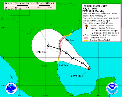
 As of 7PM EDT, Tropical storm Dolly is located about 23 degrees north and 94 degrees west, taking a temporary jog to the west at 16 MPH, and with winds sustained at 50 MPH with higher gusts. Dolly has been organizing it self this evening as it continues to move towards the west-northwest. The current environmental conditions are a stimulus for rapid intensification for tropical cyclones. Low wind shear, warm sea surface temperatures, and adjacent ridge of high pressure nearby provide the perfect for Dolly to rapidly strengthen. By tomorrow morning, Doll should be a strong 60-70 mph strong tropical storm, and an outside chance of becoming a hurricane. Furthermore as it is about to make landfall, it should be category two hurricane, and with an outside chance of becoming a category three hurricane.
With Dolly expected to slow down significantly in forward speed, heavy rainfall with amounts of up to 4 to 8 inches are possible over southern Texas. These heavy rainfall amounts will cause a very real flood threat and this will need to be monitored very closely.
Preparedness Actions In The Hurricane Watch Area:
Double and triple check items in your emergency supply kit.
Make sure your vehicle has a full tank of gas.
Reinforce your garage doors and cover windows with plywood.
Secure mobile home tie downs.
Store lawn furniture and other loose light weight objects such as garbage cans and garden tools.
Finally, make sure to follow instructions, including evacuation orders, issued by local officials.
src="http://pagead2.googlesyndication.com/pagead/show_ads.js">