6:48 AM


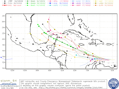
 Sporadic robust showers and thunderstorm active associated with a tropical wave about 150 miles south of Hispaniola. This system is currently moving towards the west at about 20 miles per hour, and is expected to move generally west-northwest later on. Invest 94L is moving into a more conductive environment over the next couple of days, as wind shear will decrease, sea surface temperatures will increase, and is slowly moving away from South America. Due to its low latitude, invest 94L had a difficult time of taking advantage of the diurnal maximum phase these past few days, as it was pulling cooler stable air from south America due to the fact that it was too close to it. Indeed, 94L will have to be watch closely over the next couple days as it will slowly develop, specifically the individuals who live from the Bay of Campeche to the Gulf of Mexico. The GFDL model forecast 94L to strengthen into a dynamic tropical cyclone and approach Louisiana next week. Nonetheless, this is highly inaccurate because forecasts that far out is like a needle in a haystack.
An area of low pressure located just east of Georgia is in association with some thunderstorm activity on its eastern side, and lacks convection at its western side being over land. Of course, we should expect thunderstorm activity to burst over the western side as the land will reach its peak diurnal phase this afternoon. This system has only about 40 percent chance of developing because of its proximity to land.
Some of the computer models continue to pinpoint tropical cyclone formation off the African coast next week. This area will have to be watched.