7:58 AM
Figure2- Invest 92L possible track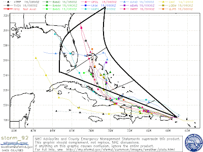

Figure 1- Invest 92L Infrared

Invest 92L continues to move west about 10-15 miles per hour, and is located just near of the Puerto Rican coast. The hurricane hunters flew into this system yesterday, however did not find a sufficiently closed circulation. During the maximum diurnal phase last night, this system has produced a vast amount of thunderstorm activity to the southeast of its center of circulation. Thus, the center of circulation still looks somewhat exposed, as it lacks convection. Nevertheless, according to the latest satellite imageries it does became apparent that increased low level convergence near the center of circulation is causing more thunderstorms to form. Of course, the development of thunderstorms near the center circulation will have a feedback effect, and allow this system's rate of intensification to increase. The development of thunderstorms accelerate the updrafts to move faster at higher altitudes, and eventually diverge it will diverge once it reaches a certain level. As divergence becomes more dynamic due to good convergence, the air pressure will steadily began to fall. As the atmospheric pressure falls, the pressure gradient force (PGF) takes over. Since the air pressure is much lower than its surroundings, air will start to rush towards it. As the rushing air tries to reach the low pressure the center, the Coriolis Effect takes over and it rotates around the low pressure center. It will also rise due to the instability, and diverge at lower levels. Yes my friends this one of the fundamental processes in cyclogenesis. Sorry for going too far off subject. The forecast track for 92L is still somewhat uncertain, but the track models have shifted west. Areas such as the Bahamas, Florida, South Carolina, Georgia are at risk.