6:54 AM
Powerful Tropical Cyclone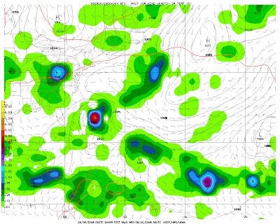

Location 10-16 Days From Now

Initial current Jet Stream Location

The tropical Atlantic is currently quiet and no significant tropical cyclone development is expected for the next 24-36 hours. However by the next week, the tropical Atlantic is expected to become very active as the apex of hurricane season nears.
The computer models unanimously forecast a substantial tropical cyclone near 30-40 degrees west about 48-60 hours from now. The environment will allow the tropical cyclone to grow more dynamic, symmetrical, and well established poleward and equatoward outflow due vigorous convergence and divergence. The sea surface temperatures are sufficiently warm to cause robust convection, upper level winds are low enough to keep the center of circulation intact, and the anticyclonic flow from the Azores high will provide great upper level divergence. Indeed, this kind of environment is where tropical cyclones thrive and "breathe", and thus significant intensification is a possibility.
Yet, where will this system go? Should be one of the momentous questions that should be asked right now. This system is right beneath the Azores high, consequently it will move generally towards the west and west-northwest during the next 7 days. Nevertheless beyond that, the forecast path possibility becomes to ambiguous to be considered efficient.
For a long time now, the jet stream dipped far to the south and has been stuck like that. As a result troughs of low pressures dig farther south than usual for this times of year. This does explain tropical cyclone Edouard form last week. When the jet streams dips that far south, the likelihood of tropical cyclones curving out to sea is much higher, but how long will that pattern last?
During the previous runs by the GFS model, it has been indicating that this "dip" in the jet streams will not be present about 10-16 days from now. At the end of that period, the GFS forecast it to far north.
The best thing we can do now is watch the tropics closely.
It should be noted that the GFS develops another tropical cyclone after this system develops.
$$
Jean-Baptiste